UK weather: 32 FLOOD ALERTS issued as Met Office warns of SNOW AND RAIN to plague Britain
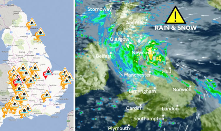
The Met Office have issued a yellow warning for snow and rain in northern parts of the nation that could “make journey times longer”.
The warning reads: “Scattered snow showers will affect northern Scotland during the early hours of Tuesday morning.
“A spell of persistent rain and hill snow is expected to develop through Tuesday morning across southern Scotland, extending into northern Scotland in the afternoon and evening.
“Delays to travel and public transport could occur from snow on higher ground.
“Spray and flooding on low level roads will probably make journey times longer.”
Meanwhile, the Environment agency has issued 32 flood alerts and 2 flood warnings that are spread across the country.
Areas where flooding is “possible” are Bow and Piddle Brook, Ledwyche Brook and River Rea, Lower Avon and Tributaries, Lower River Soar in Leicestershire, Lower Tone and Parrett Moors, Mid Bristol Avon Area, Poole Harbour, Rea Brook and Cound Brook, River Chew catchment, River Dene in South East Warwickshire, River Esk, River Frome in Herefordshire, River Leadon Catchment, River Leam and River Itchen, River Lugg south of Leominster, Rivers Clyst and Culm and their tributaries, Rivers in the Forest of Dean, River Sow and River Penk, River Tone Catchment, River Yeo and River Parrett Moors around Muchelney and Thorney, South East Somerset Rivers, Upper Reaches, South Somerset Rivers, Upper Reaches, The Rivers Blyth and Walpole and Chediston, Bramfield and Wrentham watercourses, The Rivers Deben and Lark, The River Waveney from Diss and the River Dove to Ellingham, including Bungay, The upper Rivers Yare, Tiffey, Tas and Wacton, Tidal Thames riverside from Putney Bridge to Teddington Weir, Upper Avon River Swift and Clay Coton Brook, Upper Bristol Avon Area, Upper Tame, Upper Teme, Wear Estuary.
North Bank Road alongside the River Nene, east of Peterborough and west of Dog-in-a-Doublet Sluice and River Frome at Bromyard are warned against flooding – residents in these areas are encouraged to take immediate action.
An area of low pressure is responsible for the colder air that will help turn rain to snow in the north.
Met Office meteorologist Aidan McGivern explained: “As we begin Tuesday an area of low pressure brings an area of rain into northern England, southern Scotland and Northern Ireland and as it bumps into colder air we will see snow over the hills… by the morning it’s pushing into the Central Belt.
“However, by the afternoon the snow is across central and eastern Scotland and where we see prolonged rain set in at lower levels 20 to 30millimetres accumulating by the end of Tuesday and above 200 or 300metres or so, that will be snowfall and again significant accumulations across eastern parts of Scotland in particular.
“The far north and north-west of Scotland will be brighter but colder and a brisk easterly wind will make it feel cold.
“Further south there will be sunny spells, the odd shower, however here across much of England and Wales temperatures will reach double figures.
“Low pressure remains in charge on Tuesday night.
“The bad weather in the far-north becomes confined to the northern isles and the far north of the mainland and elsewhere there will be clear skies for many, but further showers will push back in to western parts of the British Isles.”
While the north sees dismal weather, conditions will be severely better in the south that is set to see sunshine.
Mr McGivern went on: “With light winds, particularly across central and south-eastern England, a frost and some dense fog patches will begin Wednesday.
“For the far north there will be some wet weather for the Northern Isles and far north of the mainland, again hill snow here, but for most actually Wednesday is a brighter day.
“There will be some sunshine and just a scattering of showers pushing through.
“Some of these showers will be slow moving and heavy, but in the sunshine temperatures not feeling too bad.
“A slow return to slightly more normal temperatures as we go through the week.
“There will be lots going on over the next few days, a lot of rainfall and snow melting at lower levels.
“Further hill snow in the north.”
You may be interested

Johnny Depp on ‘challenge’ of playing King Louis XV in Jeanne du Barry – Exclusive
admin - Apr 19, 2024[ad_1] After the film's debut at Cannes last year, Johnny Depp’s latest movie lands in UK cinemas today.The Pirates of…

Zara Tindall packs on the PDA with husband Mike as royal fans swoon over 'fabulous' outfit
admin - Apr 19, 2024[ad_1] Zara and Mike Tindall put on a loved-up display as they attended the second day of the Cheltenham Racecourse…

Henry Cavill finally speaks out on next James Bond casting rumours
admin - Apr 19, 2024[ad_1] Back in 2005, Henry Cavill scored a rising star’s dream after bagging a secret James Bond audition.Yet despite having…
Leave a Comment
You must be logged in to post a comment.
Featured Post