Hurricane Gordon path LIVE updates: Gordon to SMASH Mississippi and Gulf TONIGHT
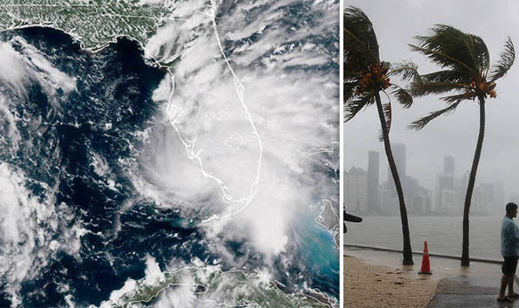
Tropical Storm Gordon is set to become a Category 1 hurricane as it ploughs into land on Tuesday night.
The massive storm is packing maximum sustained winds of 65mph (100km/h), just 9mph from hurrican-strength, and is heading northwest at 15mph (24km/h).
Gordon is forecast to uneash a torrent of hazards when it hits, including torrential rain, powerful winds, life-threatening strom surges and tornadoes.
Mississippi Governor Phil Bryant and Alabama Governor Kay Ivey both declared a states of emergency as the storm bore down.
The following watches and warnings are in place:
- A Storm Surge Warning is in effect for: Shell Beach to Dauphin Island
- A Storm Surge Watch is in effect for: West of Shell Beach to the Mouth of the Mississippi River, and East of Dauphin Island to Navarre
- A Hurricane Warning is in effect for: Mouth of the Pearl River to the Alabama-Florida Border
- A Tropical Storm Warning is in effect for: West of the Mouth of the Pearl River to Grand Isle, including Lake Pontchartrain and Lake Maurepa, and Alabama-Florida Border to Okaloosa-Walton County Line
Follow us below for all the live updates as the situation progresses. All update times in BST (six hours behing Central Standard Time)
7.25pm BST (1.25pm CST) update: Latest NOAA advisory says ‘squally’ weather hits as hurricane builds
The latest advisory from the National Oceanic and Atmospheric Administration (NOAA) said: “Outer rain-bands are producing squally weather along the coast of the western Florida panhandle.
“Gordon is expected to make landfall tonight as a hurricane.”
At 10am Central Time (4pm BST) on Tuesday, Gordon was churning about 145 miles (235km) east-southeast from the mouth of the Mississippi River.
The massive storm is packing maximum sustained winds of 65mph (100km/h) and is heading northwest at 15mph (24km/h).
NOAA forecasts the storm to continue on its current heading into Tuesday night along the north-central Gulf coast.
A northwestward motion with some decrease in forward speed is expected after landfall, with a gradual turn toward the north-northwest.
On the forecast track, the centre of Gordon will move across the northern Gulf of Mexico, approaching the north-central Gulf Coast late on Tuesday, before moving inland over the lower Mississippi Valley into Wednesday.
You may be interested

Tesla plans to charge some Model Y owners to unlock more range
admin - May 05, 2024[ad_1] Tesla CEO Elon Musk posted on Friday that the Standard Range rear-wheel drive Model Y the company has been…

Anchorman star invests in Leeds United
admin - May 05, 2024[ad_1] Will Ferrell has become the latest celebrity to invest in Leeds United - joining Gladiator star Russell Crowe and…

Microsoft says it did a lot for responsible AI in inaugural transparency report
admin - May 03, 2024[ad_1] In its Responsible AI Transparency Report, which mainly covers 2023, Microsoft touts its achievements around safely deploying AI products.…
Leave a Comment
You must be logged in to post a comment.