UK snow radar LIVE update: Map shows freezing weather system hit London and SMASH UK coast
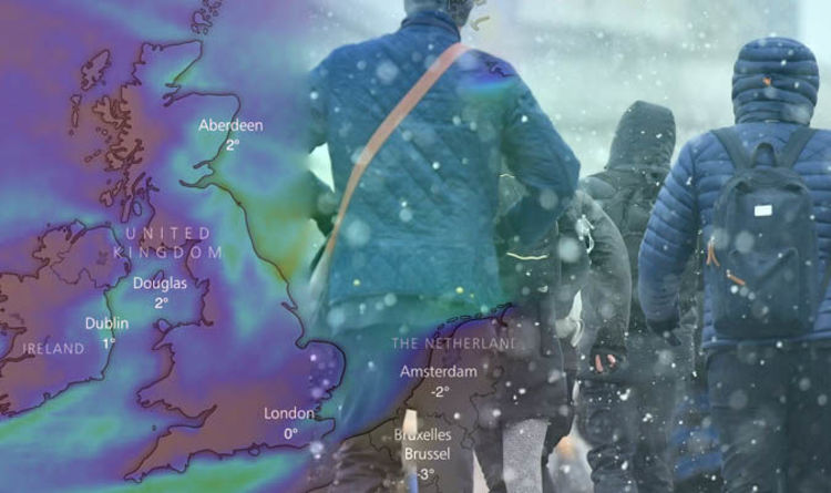
Some parts of the UK are set to feel colder than places in the Arctic Circle this week as the freezing temperatures are swept in by the so-called beast from the East.
Widespread snow is forecast and the Met Office has issued yellow weather warnings for Monday, Tuesday, Wednesday and Thursday.
By the end of Wednesday, more than 20cm of snow may have accumulated in some parts of eastern England, Scotland and Northern Ireland.
Met Office meteorologist Charlie Powell said: “The UK is on track for some really cold weather this week. It’s not going to be record-breaking, but it’ll be pretty exceptional – winds are going to make it feel minus 10C (14F) to minus 15C (5F) during the day.”
Express.co.uk brings you the latest news and updates about the snow LIVE below. All times in GMT.
UK weather snow LIVE: Fresh waves of snow have already fallen in London
 WINDY – PA
4.52pm: High Wycombe and Ispwich weather warning issued – Kent County Council issue snow emergency Snow is also currently falling in Ipswich before temperatures plummet overnight. Snow is expected to cause a lot of disruption of roads, trains and at airports. Kent County Council has declared a ‘snow emergency’ to severe weather conditions. 4.51pm: Met Office warns – this is just the beginning UK Outlook for Tuesday 13 Mar 2018 to Tuesday 27 Mar 2018: A blocked pattern remains most likely across much of the UK, with colder than average conditions, but possibly milder at times in the south and southwest. Further bitterly cold easterly winds are probable, giving a significant wind chill. There will continue to be a risk of snow across some central and northern areas, but in the far north and northwest it should be drier. Frosts will continue to be widespread and severe in places. As we head towards the middle of March it may turn more unsettled and less cold with milder and wetter weather spreading up from the south or southwest. This may lead to further significant snow in places although this remains very uncertain. Northern areas may hang on to the colder weather well into March. 4.50pm: Met Office update Between 16:00 Mon 26th and 23:55 Mon 26th Snow showers, already affecting eastern parts of England, are expected to become more persistent and heavier through late Monday afternoon and evening. There is the potential for travel delays on roads, as well as delays or cancellations to rail and air travel. Power cuts may also occur and other services, such as mobile phones, may be affected. Snow radar: 4.40pm snow forecast map – LIVE Snow is currently falling in Oxford. A weather warning is currently in place for the university city. 4.00pm update: Snow flurries gather on Kent coast Latest real-time snow radar maps for the South East show snow flurries gathering just off the Kent coast. A heavy blizzard is expected to hit much of Kent and South East London overnight and into the morning. Forecasters are expected snow to hit from around 6pm onwards. 3.43pm update: Temperature overnight – below freezing Temperatures up and down the country will dip significantly below 0C as the Beast from the East sweeps through on Tuesday morning, according to BBC Weather. Early tomorrow temperatures will range between -3C to -4C in the South of England, and between -1C and -4C further up north. By Tuesday afternoon temperatures will stabilise somewhat, rising back in many places above 1C. The Met Office has meanwhile urged motorists to expect travel disruptions overnight and Tuesday morning. Between five and 10cm of snow is possible by 11am on Tuesday in the South East of England, with localised accumulations of up to 15cm. Snow radar 3:45pm update: Snow flurries gathering towards Kent 3.35pm update: Tuesday morning forecast Road conditions across paths of Northern England are expected to significantly deteriorate. The Met Office warned: “Heavy snow plus strong winds will give some very difficult travel conditions across parts of northern England during Tuesday morning. “Five to 10 cm of snow is likely so take extra care when out and about.” 3.30pm update: Met Office snow update: Warning for London and South East England Snowy showers across the eastern parts of England will likely intensify through Monday afternoon and evening. The Met Office said: “ There is the potential for travel delays on roads, as well as delays or cancellations to rail and air travel. “Power cuts may also occur and other services, such as mobile phones, may be affected.” There is potential for frequent but small snow accumulations between 0 and 2cm, but localised areas can witness up to 5cm. 3pm: Sebastian Kettley takes over live reporting from Amani Hughes. Snow LATEST: Thermometers up and down the country will plummet overnight 2.40pm update: Google searches rise for snow boots, snow chains and snow socks for cars Google has registered an increase in the number of searches in the UK for snow boots and snow chains for cars as Britons rush to prepare for the freezing cold temperatures overnight and into tomorrow. Snow is now currently falling heavily in East Anglia while Kent is getting a few hours of repose before heavy snow hits tonight. WX Charts forecasters said today: “Temperatures really struggling across Europe. Dewpoints are incredibly low, even minus double-digits in England currently.” 2.22pm update: Snow flurries beginning to thin ahead of deluge in South East this evening Blizzards are beginning to thin across the north east coast of England while snow still falls in London. Train operators have warned to be homebound before 6pm ahead of a snow deluge this evening. Forecasters have predicted a snow squall to hit the country tomorrow morning. Snow radar UK: Dew points are reaching critically low levels across Europe 2.17pm update: Snow falling in Cambridge Snow is currently falling in Cambridge. Britons are taking to social media to share pictures of snow snaps taken at Selwyn College, Cambridge.
With the freezing temperatures forecast for the coming days a Severe Weather Emergency Protocol (SWEP) is in place in Cambridge. 1.45pm update: England and Wales likely to see coldest spell of weather since at least 2013 England and Wales should be prepared to see the coldest spell of weather since at least 2013 – perhaps 1991, Met Office’s chief forecaster Frank Saunders said. He said: “This will lead to dangerous conditions on roads and pavements and have an impact on people’s health. “There is the potential for disruptive snowfall in many parts of the country throughout the week with the areas most at risk being eastern England and eastern Scotland. Transport disruption is likely in areas with signifiant snowfall.” Snow radar map: 2pm UK snow radar shows flurries in pink UK snow map: Chart shows air mass temperature – where our air now originates from Siberia 1.27pm update: Met Office update Met Office chief forecaster’s assessment: Further snow showers are expected through Tuesday, with the likelihood that a more organised area of snow will push southwest during the morning, bringing 5 to 10cm of snow in places in just a few hours. Strong winds may lead to drifting of lying snow especially over hills, with lightning perhaps an additional hazard near North Sea coasts. 1.12pm update: Forecasters are warning do not underestimate the snow impact Forecasters have warned not to underestimate the impact of the weather through the coming days. Exacta Weather’s James Madden said: “These widespread and heavy snow showers will continue through much of next week and beyond, and it is likely that it will be snowing somewhere on the British Isles for several days in succession without stopping. “The snow will also fall to much lower levels of the country and this is likely to lead to some notable accumulations and school closures/travel disruption.” Snowfall at 1.13pm across the UK 01:03pm update: Snow falling on the east coast The below map from Meteo Radar shows snow falling – in pink – across the east coast of Britain with heavy snow continuing to fall in the South East after blizzards hit this morning. Areas north of Newcastle and along the east coast toward Berwick are currently experiencing snow flurries and strong gales as temperatures plummet to 2C. The temperature in London is 1C at the moment while in Edinburgh temperatures are hitting 3C. 12:42pm update: Snowfall in Surrey and West Sussex Snow is currently falling in the Crawley-Croyden corridor. With more than 18 inches expected in the surrounding area, parts of Surrey and Kent will feel the full force of the Beast from The East. Am amber weather warning has been issued for parts of Kent and the South East. Sittingbourne, Maidstone and Gillingham in Kent will get a heavy coating overnight. Reports of snow also falling in Kings Lynn. UK snow real-time radar at 13:02: Key – pink – snow falling white – rain and snow Snow fall at 12:55pm across the UK 11.30am update: Forecast for Friday’s snowfall The WXCharts map below shows the expected snowfall on Friday, following a week of weather warnings. 11.30am: Emergency shelters opened for homeless Emergency shelters have been opened for the homeless as freezing conditions and snow hit the UK. Councils across Britain are offering extra accommodation to rough sleepers, whose lives are at risk on the streets. During extremely cold weather, when temperatures fall to zero degrees or lower for three days, special measures come into action with the Severe Weather Emergency Protocol (SWEP). Mayor of London Sadiq Khan said emergency shelters “ensure people sleeping rough have somewhere warm to stay through the cold weather forecast this weekend and next week”. In the capital extra support can be implemented when the temperature drops below freezing for one night and other facilities are full. Snow depth expected to hit 35cm in parts of the UK 11am: Train delays and cancellations Hannah Maundrell, Editor in Chief of money.co.uk, said: “The ‘Beast from the East’ is already causing travel disruption to transport networks in the UK and the worst is yet to come later this week. If bad weather means your train is cancelled make sure you get a full refund. You’ll need to keep hold of your unused train tickets and claim for a refund within 28 days. “If your train is delayed by more than 15 minutes you could claim compensation, so make sure you submit a claim. The amount of compensation you’ll get depends on who you were travelling with. Some companies may give you compensation after just a 15 minute delay so it’s worth checking. “Thanks to the Delay Repay scheme most train firms will compensate you even if bad weather is to blame.” 10am: Public Health England issues health warnings Public Health England (PHE) has issued cold weather alerts and health warnings following the arrival of the cold weather. Dr Thomas Waite, of PHE’s Extreme Events team, said: “Cold temperatures, indoors and out, pose real health risks to many and every winter we know that thousands of people get ill and even die following exposure to cold conditions. “As forecasters tell us next week temperatures will fall, it’s critical that if you know anyone over 65, with young children or who has heart or lung conditions, that you keep an eye on them and think what help they may need. Staying warm by heating your home to at least 18°C can be crucial to stay well.” Freezing gales blasting across Britain at 12:57pm on Monday 9am: Odds slashed on coldest March ever Bookmaker Coral has slashed the odds on next month ends as the coldest March on record to 6-4 (from 2-1) as the country freezes in the face of the ‘Beast from the East’. “It’s going to be a bitterly cold start to March with the cold showing no signs of letting up and we think there’s now a real possibility of it being a record breaking month for the low temperatures,” Harry Aitkenhead from Coral said. “The firm make it odds on, at 10-11, that 2018 ends as the coldest year on record following a flurry of bets since the turn of the New Year. “Our odds have tumbled since the start of the year on 2018 being the coldest ever and if this keeps up it’ll be a near certainty.” 8.30am: Beast from the East arrives The ‘beast from the east’ has officially arrived in the UK as some parts of the UK are set to feel colder than the Arctic Circle as freezing temperatures continue into the week ahead. Amber warnings of snow have been issued by the Met Office for north east, central and south eastern England on Tuesday, and eastern Scotland on Wednesday. It warned of “heavy snow showers”, with a spokesman adding: “Travel delays on roads are likely, stranding some vehicles and passengers. “Some delays and cancellations to rail and air travel are likely. “There is a good chance that some rural communities could become cut off. “Power cuts are likely and other services, such as mobile phones, may be affected.” Widespread snow is forecast, and the Met Office has issued yellow weather warnings for Monday, Tuesday and Wednesday. By the middle of the week, the majority of Britain is being warned of the potential for delays on the roads, trains and in the air. A less severe yellow warning for snow is in place from Monday to Wednesday.
 Netweather
 Meteo radar
 BBC WEATHER
 WX Charts
 Meteoradar
 WXCHARTS
 Netweather
 MeteoRadar.co.uk
 UKsnowmap
 WX Charts
 Windy.com
Monday, February 26

You may be interested

Microsoft says it did a lot for responsible AI in inaugural transparency report
admin - May 03, 2024[ad_1] In its Responsible AI Transparency Report, which mainly covers 2023, Microsoft touts its achievements around safely deploying AI products.…

Sainsbury’s, Marks and Spencer and Tesco opening times this Bank Holiday weekend in full
admin - May 03, 2024[ad_1] The UK's five major supermarkets have warned customers of store closures over this weekend. None of them are expected to shut entirely…

Barclays warns ‘be cautious’ of increase in ‘harmful’ scam most people don't spot
admin - May 03, 2024[ad_1] Barclays is warning Britons to be vigilant of a “harmful” mobile phone malware scam that most people are unaware they’re…
Leave a Comment
You must be logged in to post a comment.
Featured Post